We deliver advanced satellite-based analytics, predictive modeling, and actionable insights to support smarter decisions and sustainable development.
how satellite remote sensing Technology using in precision farming
Our advanced satellite remote sensing technology brings precision farming to every field—monitoring crop growth, soil moisture, and water requirements with unmatched accuracy. From identifying early signs of crop stress to estimating fertilizer needs and predicting yield,
We convert every pixel of satellite data into actionable insights. Farmers receive timely advisories that help them optimize irrigation, reduce chemical use, improve soil health, and ultimately increase crop production. With Terraflux, smart farming isn’t the future—it’s happening now, from seed to harvest.

01. Precision Farming
Precision farming combines modern technology and traditional farming wisdom to optimize crop yields, reduce waste, and minimize resource usage. By leveraging tools like satellite imagery, drones, and real-time data, we can monitor and adjust every aspect of crop production, ensuring maximum efficiency and sustainability. Key Benefits of Precision Farming: Improved Resource Efficiency: Optimize the use of water, fertilizers, and pesticides.
Increased Yield: Maximize crop production by addressing specific plant needs.
Cost Savings: Reduce input costs through data-driven decision-making.
Sustainability: Lower environmental impact by using resources more efficiently.
Real-Time Monitoring: Continuously track crop health and growth stages.
Predictive Analytics: Forecast weather patterns, pests, and nutrient deficiencies.
Precision Farming –
Precision farming combines modern technology and traditional farming wisdom to optimize crop yields, reduce waste, and minimize resource usage. By leveraging tools like satellite imagery, drones, and real-time data, we can monitor and adjust every aspect of crop production, ensuring maximum efficiency and sustainability.
- Key Benefits of Precision Farming:
- Improved Resource Efficiency: Optimize the use of water, fertilizers, and pesticides.
- Increased Yield: Maximize crop production by addressing specific plant needs.
- Cost Savings: Reduce input costs through data-driven decision-making.
- Sustainability: Lower environmental impact by using resources more efficiently.
- Real-Time Monitoring: Continuously track crop health and growth stages.
- Predictive Analytics: Forecast weather patterns, pests, and nutrient deficiencies.
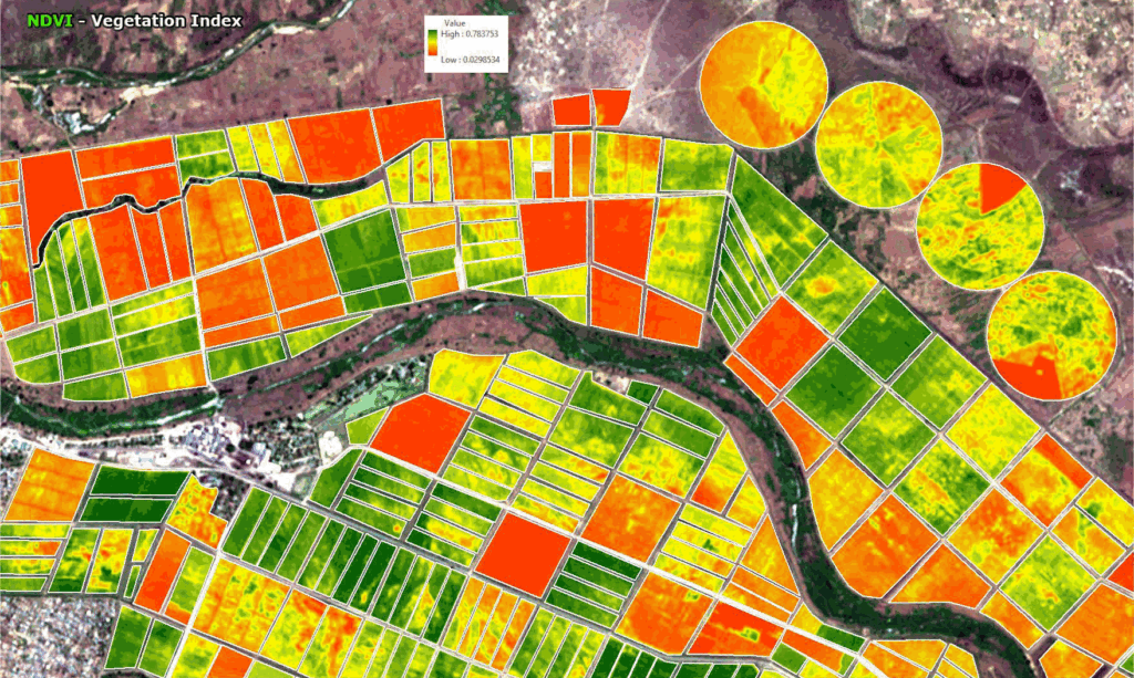
02. Crop Monitoring (NDVI, chlorophyll, moisture)
Gain a deeper understanding of your crop’s health with high-resolution satellite analytics. Terraflux provides continuous monitoring using NDVI, chlorophyll indices, and surface moisture data to identify crop stress early, optimize inputs, and support smarter farm management decisions.
03. Soil Health & Nutrient Mapping
Healthy soil is the foundation of productive farming. Terraflux provides advanced geospatial tools to map soil health parameters and nutrient availability, helping farmers manage their fields with precision and sustainability. By integrating satellite data, field measurements, and predictive modeling, we deliver actionable insights to improve soil fertility and crop performance.

04. Irrigation & Water Use Efficiency
Efficient water management is essential for sustainable agriculture. Terraflux uses satellite analytics, moisture indices, and geospatial modeling to help farmers optimize irrigation schedules, reduce water wastage, and improve crop health. Our solutions ensure every drop of water is used wisely for maximum productivity.

05. Pest & Disease Detection
Our satellite-based analytics help identify early signs of pest attacks and crop diseases before they become visible on the ground. By analyzing changes in crop colour, canopy health, and vegetation indices, we detect stress patterns quickly and accurately.
This allows farmers to take timely, targeted action—reducing crop loss, minimizing chemical usage, and improving overall farm productivity.

06. Yield Estimation
Our advanced satellite analytics accurately predict crop yield well before harvest. By monitoring plant growth, biomass levels, canopy health, and field variability, we provide data-driven yield forecasts that help farmers plan better.
From market planning to resource allocation, our yield estimation tools empower growers, FPOs, and agribusinesses to make informed decisions and maximize profitability.

07. Carbon & Sustainability Insights
Our satellite-driven analytics help assess, monitor, and enhance the environmental performance of farms and landscapes. By analyzing vegetation health, biomass, soil moisture, and land-use patterns, we enable climate-smart decisions that support carbon reduction, sustainability reporting, and regenerative agriculture.

08. Crop Insurance
Satellite-based monitoring brings transparency, speed, and accuracy to crop insurance processes. By continuously tracking crop growth, weather impact, and field-level anomalies, we help insurers and farmers reduce disputes, assess risks early, and accelerate claim settlements.
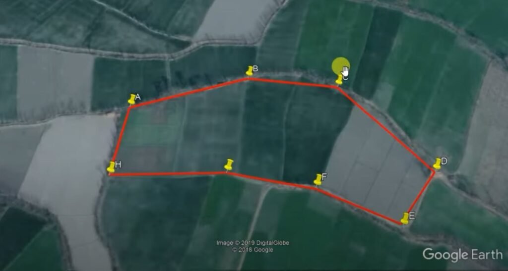
09. Farm Boundary Mapping
Accurate farm boundaries are the foundation of precision agriculture. Using high-resolution satellite imagery and drone surveys, we create precise, geo-referenced field maps that support farm planning, input management, compliance, and dispute resolution.
Technology That Lifts Agriculture to New Heights
