At Terraflux, we combine satellite analytics, drone intelligence, and AI-driven models to deliver precise, real-time insights for modern agriculture. Our technology stack integrates remote sensing, machine learning, geospatial mapping, and cloud automation to transform raw data into actionable decisions for farmers, enterprises, and government projects.
Trusted by Farmers & Businesses
At Terraflux, our commitment to precision agriculture and advanced geospatial intelligence is reflected in the satisfaction of our clients. From farmers and agri-enterprises to government agencies and research institutions,
our technology-driven solutions have delivered measurable results—improving productivity, reducing risks, and enabling smarter, data-backed decisions.

01. Satellite Data Sources (Sentinel, Landsat, etc.)
We leverage globally trusted satellite missions such as Sentinel, Landsat, MODIS, PlanetScope, and other commercial constellations to deliver reliable, continuous, and scalable agricultural insights. These multi-spectral datasets help monitor crop health, soil moisture, vegetation growth, and climate impacts across large areas with consistent accuracy. By integrating multiple satellite sources, we provide farmers and agribusinesses with timely, repeatable, and cost-efficient intelligence for better decision-making.
02. Drone & UAV Integration

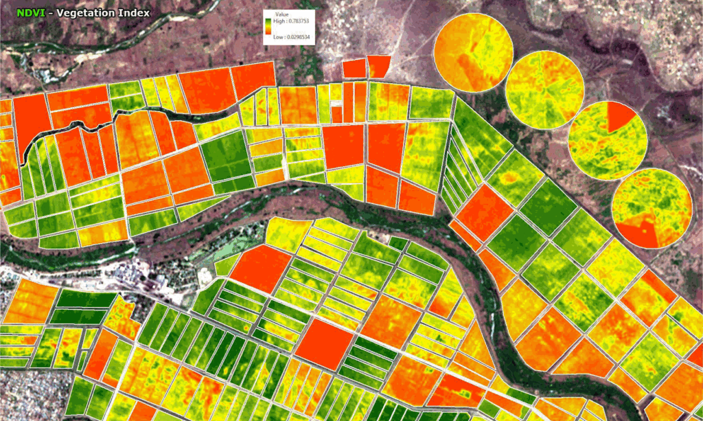
03. GIS & Remote Sensing Tools
We use advanced GIS and remote sensing tools to transform raw satellite and drone data into meaningful, actionable insights. Through spatial analysis, image processing, and geostatistical modelling, we help farmers, agribusinesses, and environmental projects make informed decisions with high accuracy. Our tools enable precise mapping, monitoring, and assessment of crops, soil, water, and landscape dynamics.

04. AI & Data Analytics
Our platform uses cutting-edge AI and data analytics to convert complex satellite, drone, and field data into clear, actionable intelligence. By applying machine learning, predictive modelling, and pattern recognition, we deliver insights that improve farm productivity, optimize resources, and support smarter environmental decisions.

05. Mobile & Web Platforms
Our mobile and web platforms provide a seamless digital experience, allowing users to monitor farms, access analytics, and make informed decisions anytime, anywhere. Designed for farmers, agribusinesses, and environmental professionals, the platform ensures fast, intuitive, and data-driven interactions powered by real-time geospatial intelligence.
")
06. IoT Sensors (Soil & Weather)
IoT-based soil and weather sensors provide real-time, on-ground data that helps farmers make precise and timely decisions. These sensors continuously monitor soil moisture, temperature, humidity, rainfall, and micro-climate conditions, enabling smarter irrigation, nutrient management, and crop protection. With accurate field-level insights, farmers can reduce risks, improve yield, and increase resource efficiency.

07. GPS & GNSS-Based Field Operations
GPS and GNSS technologies bring precision, accuracy, and consistency to modern farming. By enabling exact field mapping, guided machinery movement, and precise input placement, these systems help farmers reduce wastage, save time, and improve overall productivity. Whether it’s planning field boundaries, monitoring farm activities, or executing machine operations with sub-meter accuracy, GPS/GNSS systems form the backbone of precision agriculture.

08. Cloud Computing & Big Data Processing
Cloud computing enables fast, scalable, and secure processing of large agricultural datasets—from satellite imagery and drone maps to weather records and IoT sensor streams. With big data analytics, complex information is transformed into actionable insights for farmers, agribusinesses, and governments. This technology supports real-time decision-making, automation, predictive modelling, and seamless integration across all precision farming tools.
-02")
09. Variable Rate Technology (VRT)
Variable Rate Technology allows farmers to apply inputs—such as fertilizers, seeds, pesticides, and irrigation—at precise rates based on the unique conditions of each part of the field. Using satellite maps, soil data, drone imagery, and AI-driven analytics, VRT optimizes resource use, reduces waste, and increases productivity. It transforms conventional farming into data-driven, site-specific management for better yield and sustainability.
